
State Map of Armenia
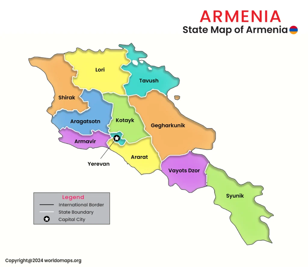
Armenia, a landlocked country in the South Caucasus, is divided into ten provinces, known locally as marzes, along with the capital city of Yerevan, which holds special administrative status equal to a province. Each marz is headed by a governor (marzpet) appointed by the national government, while Yerevan is governed by an elected mayor. This structure reflects Armenia’s mix of mountainous rural regions and a single dominant urban center.
Major Provinces and Regional Significance:
Yerevan – As Armenia’s capital and largest city, Yerevan holds special administrative status separate from the ten provinces. It is the country’s political, economic, and cultural heart, home to over a third of the national population and landmarks such as Republic Square and the Cascade complex.
Aragatsotn Province – Named after Mount Aragats, Armenia’s highest peak, this province is known for its alpine landscapes and ancient monasteries, including Hovhannavank and Saghmosavank, perched above the Kasakh Gorge.
Gegharkunik Province – Armenia’s largest province by area, Gegharkunik surrounds Lake Sevan, the largest lake in the South Caucasus and a major tourism and freshwater resource for the country.
Lori Province – Located in the north bordering Georgia, Lori is an industrial and mining region historically tied to copper production, and home to the medieval Sanahin and Haghpat monasteries, both UNESCO World Heritage Sites.
Syunik Province – The southernmost and second-largest province, Syunik is a mountainous, forested region bordering Iran and Azerbaijan’s Nakhchivan exclave. It is known for the Tatev Monastery and the “Wings of Tatev” aerial tramway.
Shirak Province – Home to Gyumri, Armenia’s second-largest city, Shirak is a cultural and educational center known for its distinctive black-tuff architecture and its history of surviving the devastating 1988 earthquake.
Vayots Dzor Province – A major wine-producing region, Vayots Dzor is home to the Areni-1 cave complex, site of the world’s oldest known winery, as well as the spa town of Jermuk and the Noravank monastery.
Tavush Province – Bordering Georgia and Azerbaijan, Tavush is a forested, mountainous province sometimes called “Little Switzerland” for its alpine scenery, and includes the resort town of Dilijan.
Kotayk Province – Situated just east of Yerevan, Kotayk combines industrial towns like Hrazdan and Abovyan with cultural sites including the 1st-century pagan Temple of Garni.
Ararat Province – Named for the plain and mountain visible from its territory, Ararat Province is an agricultural heartland south of Yerevan, known for its fruit orchards and brandy production.
Armavir Province – Armenia’s smallest province by area, Armavir is home to Vagharshapat (Etchmiadzin), the spiritual center of the Armenian Apostolic Church and seat of its Catholicos.
Armenia’s Provinces: Capitals, Area, and Prominent Cities
This table provides an overview of Armenia’s ten provinces and the capital city of Yerevan, including capitals, area, codes, and major cities.
| No. | Province | Capital City | Area (sq. km) | Code | Major Cities |
|---|---|---|---|---|---|
| 1. | Yerevan | Yerevan | 223 | AM-ER | Yerevan |
| 2. | Aragatsotn Province | Ashtarak | 2,753 | AM-AG | Ashtarak, Aparan, Talin |
| 3. | Ararat Province | Artashat | 2,090 | AM-AR | Artashat, Masis, Ararat |
| 4. | Armavir Province | Armavir | 1,242 | AM-AV | Vagharshapat, Armavir, Merdzavan |
| 5. | Gegharkunik Province | Gavar | 5,349 | AM-GR | Gavar, Sevan, Vardenis |
| 6. | Kotayk Province | Hrazdan | 2,089 | AM-KT | Hrazdan, Abovyan, Charentsavan |
| 7. | Lori Province | Vanadzor | 3,799 | AM-LO | Vanadzor, Stepanavan, Alaverdi |
| 8. | Shirak Province | Gyumri | 2,680 | AM-SH | Gyumri, Artik, Maralik |
| 9. | Syunik Province | Kapan | 4,506 | AM-SU | Kapan, Goris, Sisian |
| 10. | Tavush Province | Ijevan | 2,704 | AM-TV | Ijevan, Dilijan, Noyemberyan |
| 11. | Vayots Dzor Province | Yeghegnadzor | 2,308 | AM-VD | Yeghegnadzor, Jermuk, Vayk |