Menu
State (Provinces) Map of Canada
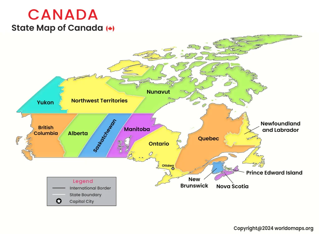
Canada, the second-largest country in the world, is divided into 10 provinces and 3 territories. These divisions play a vital role in the country’s governance, economy, and cultural identity. The capital city, Ottawa, is located in Ontario and serves as the political hub of the nation. Each province and territory has a unique landscape, ranging from vast forests and mountains to coastal regions and arctic tundra.
Major Provinces and Regional Significance:
- Ontario: The most populous province, home to the capital city Ottawa and Canada’s largest city, Toronto.
- Quebec: A French-speaking province with a distinct cultural identity, known for Montreal and Quebec City.
- British Columbia: A coastal province with a strong economy, Vancouver is its largest city and a key trade center.
- Alberta: Known for its oil and natural gas industry, with major cities Calgary and Edmonton.
- Manitoba & Saskatchewan: The prairie provinces, vital for agriculture and natural resources.
- Nova Scotia & New Brunswick: Maritime provinces with historic significance and coastal beauty.
- Newfoundland and Labrador: Known for its rugged coastline and offshore oil reserves.
- Prince Edward Island: Canada’s smallest province, famous for its landscapes and seafood industry.
- The Territories (Yukon, Northwest Territories, and Nunavut): Covering the northern region with sparse populations and vast wilderness.
List of Canada’s Provinces and Territories with Capitals, Areas, and Major Cities
This table provides an overview of Canada’s 10 provinces and 3 territories, including their capitals, area, and major cities.
| S No. | Province/Territory | Capital City | Area (sq. km) | Code | Major Cities |
|---|---|---|---|---|---|
|
1. |
Ontario |
Toronto |
1,076,395 |
ON |
Ottawa, Mississauga |
|
2. |
Quebec |
Quebec City |
1,542,056 |
QC |
Montreal, Laval |
|
3. |
British Columbia |
Victoria |
944,735 |
BC |
Vancouver, Surrey |
|
4. |
Alberta |
Edmonton |
661,848 |
AB |
Calgary, Red Deer |
|
5. |
Manitoba |
Winnipeg |
647,797 |
MB |
Brandon, Steinbach |
|
6. |
Saskatchewan |
Regina |
651,036 |
SK |
Saskatoon, Moose Jaw |
|
7. |
Nova Scotia |
Halifax |
55,284 |
NS |
Sydney, Dartmouth |
|
8. |
New Brunswick |
Fredericton |
72,908 |
NB |
Moncton, Saint John |
|
9. |
Newfoundland & Labrador |
St. John’s |
405,212 |
NL |
Corner Brook, Gander |
|
10. |
Prince Edward Island |
Charlottetown |
5,660 |
PE |
Summerside, Stratford |
|
11. |
Yukon |
Whitehorse |
482,443 |
YT |
Dawson, Watson Lake |
|
12. |
Northwest Territories |
Yellowknife |
1,346,106 |
NT |
Inuvik, Hay River |
|
13. |
Nunavut |
Iqaluit |
2,093,190 |
NU |
Rankin Inlet, Arviat |
Canada’s provinces and territories showcase its geographical diversity, economic strength, and cultural richness, making it one of the most unique nations in the world.