State Map of Brazil
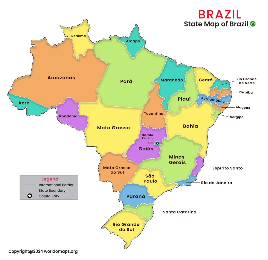
Brazil, the largest country in South America and the fifth-largest in the world, spans an area of 8,515,767 square kilometers. It is administratively divided into 26 states and a Federal District, each showcasing unique cultural, geographical, and economic characteristics. This division reflects Brazil’s immense diversity, from the Amazon rainforest in the north to the bustling urban centers in the southeast.
The capital city, Brasília, is located in the Federal District and serves as the political hub of the nation. Major cities such as São Paulo, Rio de Janeiro, and Salvador are economic and cultural powerhouses, contributing significantly to Brazil’s vibrant identity.
Major States and Regional Significance:
- São Paulo State: The economic powerhouse of Brazil, São Paulo is the most populous state and home to the financial capital, São Paulo city.
- Rio de Janeiro State: Known for its iconic landmarks like Christ the Redeemer and Sugarloaf Mountain, this state is Brazil’s tourism capital.
- Amazonas State: Covering the vast Amazon rainforest, Amazonas is crucial for biodiversity and environmental preservation.
- Bahia State: Located in the Northeast, Bahia is known for its rich Afro-Brazilian culture, historic cities, and stunning coastline.
- Minas Gerais State: Famous for its colonial towns and mineral wealth, Minas Gerais is a major agricultural and industrial hub.
- Paraná State: Located in the South, Paraná is known for Iguaçu Falls and its fertile agricultural lands.
- Rio Grande do Sul State: Bordering Uruguay and Argentina, it has a unique culture influenced by European immigration.
- Federal District: Brasília, the nation’s capital, is a planned city known for its modernist architecture and political significance.
Comprehensive List of Brazil’s States and Major Cities
This table provides an overview of Brazil’s 26 states and the Federal District, including their capitals, area, codes, and major cities.
| No. | Province | Capital City | Area (sq. km) | Code | Major Cities |
|---|---|---|---|---|---|
|
1. |
Acre |
Rio Branco |
164,123 |
North |
Rio Branco, Cruzeiro do Sul |
|
2. |
Alagoas |
Maceió |
27,768 |
Northeast |
Maceió, Arapiraca |
|
3. |
Amapá |
Macapá |
142,814 |
North |
Macapá, Santana |
|
4. |
Amazonas |
Manaus |
1,559,159 |
North |
Manaus, Parintins |
|
5. |
Bahia |
Salvador |
564,692 |
Northeast |
Salvador, Feira de Santana, Ilhéus |
|
6. |
Ceará |
Fortaleza |
148,920 |
Northeast |
Fortaleza, Sobral |
|
7. |
Espírito Santo |
Vitória |
46,077 |
Southeast |
Vitória, Vila Velha |
|
8. |
Goiás |
Goiânia |
340,111
|
Central-West |
Goiânia, Anápolis |
|
9. |
Maranhão |
São Luís |
331,937 |
Northeast |
São Luís, Imperatriz |
|
10. |
Mato Grosso |
Cuiabá |
903,357 |
Central-West |
Cuiabá, Rondonópolis |
|
11. |
Mato Grosso do Sul |
Campo Grande |
357,125 |
Central-West |
Campo Grande, Dourados |
|
12. |
Minas Gerais |
Belo Horizonte |
586,528 |
Southeast |
Belo Horizonte, Uberlândia |
|
13. |
Pará |
Belém |
1,247,689 |
North |
Belém, Santarém |
|
14. |
Paraíba |
João Pessoa |
56,439 |
Northeast |
João Pessoa, Campina Grande |
|
15. |
Paraná |
Curitiba |
199,314 |
South |
Curitiba, Londrina |
|
16. |
Pernambuco |
Recife |
98,311 |
Northeast |
Recife, Olinda, Caruaru |
|
17. |
Piauí |
Teresina |
251,577 |
Northeast |
Teresina, Parnaíba |
|
18. |
Rio de Janeiro |
Rio de Janeiro |
43,696 |
Southeast |
Rio de Janeiro, Niterói |
|
19. |
Rio Grande do Norte |
Natal |
52,797 |
Northeast |
Natal, Mossoró |
|
20. |
Rio Grande do Sul |
Porto Alegre |
281,730 |
South |
Porto Alegre, Caxias do Sul |
|
21. |
Rondônia |
Porto Velho |
237,765 |
North |
Porto Velho, Ji-Paraná |
|
22. |
Roraima |
Boa Vista |
224,300 |
North |
Boa Vista, Rorainópolis |
|
23. |
Santa Catarina |
Florianópolis |
95,346 |
South |
Florianópolis, Joinville |
|
24. |
São Paulo |
São Paulo |
248,209 |
Southeast |
São Paulo, Campinas, Santos |
|
25. |
Sergipe |
Aracaju |
21,910 |
Northeast |
Aracaju, Nossa Senhora do Socorro |
|
26. |
Tocantins |
Palmas |
277,620 |
North |
Palmas, Araguaína |
|
27. |
Federal District |
Brasília |
5,802 |
Central-West |
Brasília |